Explore practical use cases of XBLink SAT for enterprises
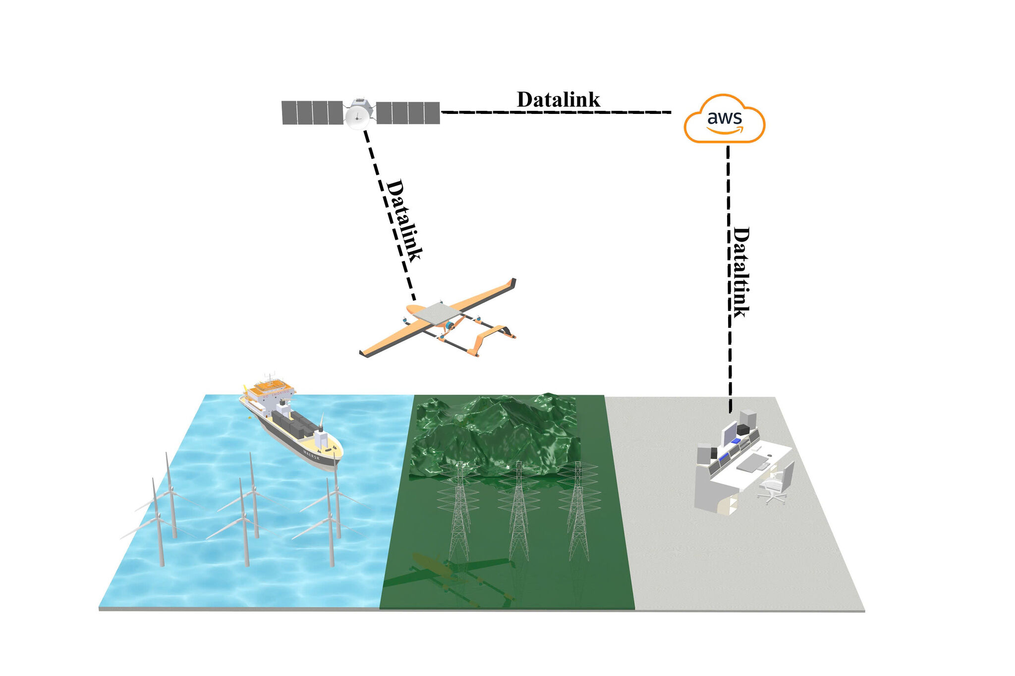
When used in remote regions or areas with weak infrastructure, UAVs can lose connectivity. In such situations, XBLink SAT, a satellite-based solution, was created to help drones transmit data and video in real time across all terrains. This allows users to deploy drones for surveillance, rescue, agriculture, and large-scale UAV fleet management. Below are the 10 most common applications of XBLink SAT for enterprises.
1. Why is satellite connectivity needed for UAVs?
In certain fields, UAVs must operate in places without mobile signals or with very poor network infrastructure. Examples include deep forests, mountainous regions, border areas, construction sites, long transmission lines, mining zones, and more.
Once connectivity is lost, data such as video or control signals can be interrupted. The drone loses signal and cannot transmit images back to the control center, making surveillance missions impossible. This is extremely dangerous in rescue operations, defense tasks, or infrastructure monitoring.
Therefore, XBStation developed XBLink to fully address this issue. With satellite connectivity, XBLink SAT can maintain stable communication across all terrains, regardless of whether the area has signal coverage or not.
2. Top 10 use cases of XBLink SAT
Below are the 10 most common use cases of XBLink SAT for enterprises:
2.1. Forest, mountain & border surveillance
In forest protection, mountainous surveillance, or border monitoring, maintaining continuous connectivity is extremely important. XBLink SAT allows drones to transmit real-time video and data back to the control center. This enables management teams to:
Monitor forest fires and issue early warnings
Detect illegal border intrusions
Observe environmental changes
Control challenging areas that ground forces cannot easily reach
This is especially useful for forest rangers, border guards, security units, and environmental agencies.
2.2. Search and rescue operations
During natural disasters such as floods or landslides, UAVs equipped with XBLink SAT can access dangerous areas that humans cannot approach. With a stable transmission line, drones can send:
Live video from landslide points
Victim locations
Terrain conditions
Water levels, toxic gas indicators, temperature
With this information, rescue teams can make quick decisions, accelerate search operations, and ensure safety for on-site forces.
2.3. Terrain surveying & mapping
Surveying, topographic measurement, and 3D mapping projects often take place in areas without telecom infrastructure. In such environments, XBLink SAT helps drones maintain uninterrupted connectivity, transmit high-quality aerial images, and synchronize data to the cloud in real time. This significantly shortens survey time and improves mapping accuracy.
2.4. Smart agriculture
Many agricultural zones are far from city centers or located in suburban areas with weak signals. XBLink SAT enables drones to maintain stable connectivity to transmit timely data, helping farmers or agricultural companies make fast decisions.
In modern agriculture, UAVs are used to:
Monitor crop growth
Detect pests and diseases
Assess moisture and irrigation conditions
Inspect large fields spanning hundreds of hectares
2.5. Infrastructure & pipeline inspection
Power lines, water pipelines, bridges, or long infrastructure systems stretching tens or hundreds of kilometers often have very weak mobile coverage.
With XBLink SAT, UAVs can:
Send continuous inspection data and video
Detect abnormalities such as cracks, leaks, or corrosion
Assist engineers in remote evaluations
Reduce costs and risks compared to manual inspection
This is a critical solution for the energy industry and national infrastructure monitoring.
2.6. Remote UAV fleet management
For enterprises operating large UAV fleets, manual management is extremely difficult. With the combination of XBLink SAT and cloud systems, businesses can:
Monitor all UAVs from a single operations center
Track flight paths, battery levels, camera and sensor status
Assign permissions to multiple pilots
Automatically store and share real-time data
This enhances safety, transparency, and operational efficiency.
2.7. Drone livestreaming for media
Livestreaming from drones in areas such as forests, islands, outdoor festivals, long-distance sports events, or remote regions with no signal is always challenging for media teams. XBLink SAT from XBStation enables stable, uninterrupted live broadcasts, ensuring high-quality news coverage and visuals.
2.8. Remote Site Infrastructure Inspection
Hard-to-access locations like mining sites, mountain power stations, telecom towers, or isolated industrial zones require remote monitoring equipment. With XBLink SAT, drones can transmit high-resolution images from hazardous spots, provide real-time reporting, and reach areas unsafe for humans. This reduces risk and increases inspection efficiency.
2.9. Delivery & logistics in no-signal regions
Although drone delivery is not yet common in Vietnam, it has already been implemented in countries like the U.S., China, and Japan. Especially in island areas, mountainous regions, sparse communities, or disaster zones with no signal, drones require stable connectivity. XBLink SAT helps delivery drones maintain accurate GPS positioning, send flight status, and report package conditions.
2.10. Environmental & wildlife research
With XBLink SAT, UAVs can observe wildlife, collect climate data, record environmental changes, and transmit continuous information to research teams. This is extremely valuable for scientists and conservation organizations.
Read more:
XBStation showcases XBLink at SEMIEXPO Vietnam 2025
XBStation welcomes representatives from a technology company
Vietnam’s 2025 low-altitude economy forum and the $10 billion industry
3. Why does XBLink SAT fit all these use cases?
XBLink SAT is designed and optimized for the needs of enterprises and professional units. The device provides stable satellite connectivity with low latency, compatibility with multiple drone models, a powerful cloud management system, and multi-directional control. It can be said that XBLink SAT unlocks expanded UAV operational capabilities for every business.
The above are the 10 most common use cases of XBLink SAT for enterprises. To purchase the product or receive technical consultation, you can contact us directly at [email protected] or via hotline (+84) 905 448 707.